ATTENTION 6TH GRADERS:
Dec 15th 2009Mr. Morphis' Class blogUncategorized
THE FIELD TRIP IS NOW ON FRIDAY MORNING. WE WILL BE TAKING THE SCHOOL BUS. WE WILL TALK ABOUT THIS IN CLASS TODAY AND WE WILL GO OVER THE DETAILS AFTER THE TEST ON THURSDAY.
"Equipped with his five senses, man explores the universe around him and calls the adventure Science." Edwin Hubble
Dec 15th 2009Mr. Morphis' Class blogUncategorized
THE FIELD TRIP IS NOW ON FRIDAY MORNING. WE WILL BE TAKING THE SCHOOL BUS. WE WILL TALK ABOUT THIS IN CLASS TODAY AND WE WILL GO OVER THE DETAILS AFTER THE TEST ON THURSDAY.
Dec 14th 2009Mr. Morphis' Class blogUncategorized
The last week before Winter Break! We will be continuing earthquakes with a TEST on Thursday over chapter 8.
The home work packet is a review for the test and we will have an all period review on Wednesday as well.
ATTENTION 6TH GRADERS: Our field trip for Thursday has been moved to Friday morning!! Details will be discussed in class.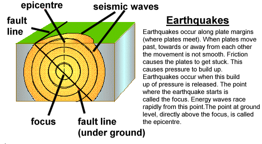
Dec 7th 2009Mr. Morphis' Class blogUncategorized
We will continue studying seismic waves this week with a “focus” on locating the epicenters and focus of earthquakes! We will plot some earthquakes on Wednesday and do a lab on epicenters on Thursday. Friday is a half day, you can enjoy your afternoon and I will be here submitting your grades…….yes it is a grading “afternoon” and progress reports will be handed out today for 4th period. 7th and 8th periods received a copy of their progress reports on Friday.
6TH GRADERS: FIELD TRIP FORM DUE FRIDAY!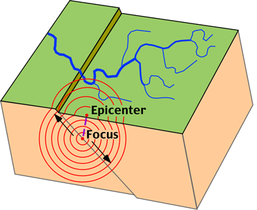
Dec 5th 2009Mr. Morphis' Class blogUncategorized
December opens the door to some very cold weather! The table below is from last night and this morning, where you can see that we just passed the 15th hour of freezing weather here in Eugene. The full weather alert is located below…….
…ARCTIC BLAST HEADED TOWARD NORTHWEST OREGON AND SOUTHWEST
WASHINGTON LATE TONIGHT AND SUNDAY…
A COLD SHOT OF ARCTIC AIR WILL ARRIVE LATE TONIGHT AND SUNDAY AS
AN ARCTIC FRONT SWEEPS WEST ACROSS THE CASCADES INTO NORTHWEST
OREGON AND SOUTHWEST WASHINGTON. DAYTIME TEMPERATURES WILL REMAIN
IN THE 30S IN MOST AREAS OF THE WILLAMETTE VALLEY AND CLARK COUNTY
SUNDAY…BUT WILL STRUGGLE TO RISE ABOVE FREEZING ON MONDAY.
OVERNIGHT TEMPERATURES SUNDAY NIGHT WILL FALL INTO THE TEENS AND
TWENTIES ALONG WITH INCREASING EASTERLY WINDS.
WIND CHILL VALUES WILL DROP SIGNIFICANTLY SUNDAY NIGHT. IN THE
COLUMBIA GORGE…WHERE WIND GUSTS UP TO 50 MPH WILL COINCIDE WITH
TEMPERATURES IN THE UPPER TEENS TO LOWER 20S…WIND CHILL VALUES
WILL DROP TO NEAR ZERO AT TIMES. SIMILARLY…WIND CHILL VALUES IN
THE SINGLE DIGITS CAN BE EXPECTED IN THE PORTLAND METRO AREA AND
CLARK COUNTY FOR AREAS NEAR THE GORGE. FINALLY…TEMPERATURES IN
THE CASCADES WILL BE IN THE SINGLE DIGITS WITH WIND CHILLS 10 TO
15 DEGREES BELOW ZERO AT THE PASSES AND RIDGES.
SCATTERED SNOW SHOWERS ARE POSSIBLE IN THE CASCADES AND THERE IS
A CHANCE THIS SYSTEM COULD BRING SOME LIGHT SNOW TO THE VALLEYS.
THIS WILL DEPEND ON HOW THE SYSTEM DEVELOPS AND HOW MUCH MOISTURE
IS AVAILABLE…BUT NO SIGNIFICANT AMOUNTS ARE EXPECTED.
IT APPEARS THAT LOW LEVEL COLD AIR WILL REMAIN IN PLACE OVER
SOUTHWEST WASHINGTON AND NORTHWEST OREGON THROUGH TUESDAY…THEN
SOME WARMING IS EXPECTED…ESPECIALLY AT NIGHT. TEMPERATURES
ALONG THE COAST WILL BE THE FIRST TO MODERATE…WITH SOME WARMING
POSSIBLE AS EARLY AS TUESDAY.
YOU SHOULD TAKE ACTION NOW TO PREPARE FOR THE VERY COLD WEATHER.
Dec 1st 2009Mr. Morphis' Class blogUncategorized
Need a Science Factory field trip permission slip? SEE ME BEFORE OR AFTER SCHOOL/CLASS, NOT DURING CLASS PLEASE!